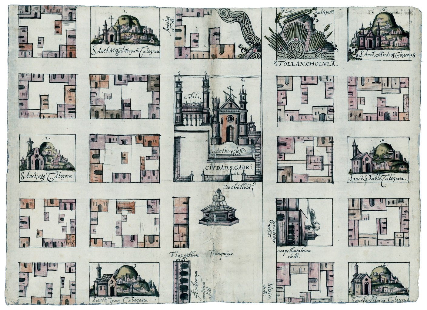
Map of Cholula, from the relaciones geográficas, 1581, 31 x 44 cm (Benson Latin American Collection, University of Texas)
Map showing the town of Cholula (underlying map © Google)
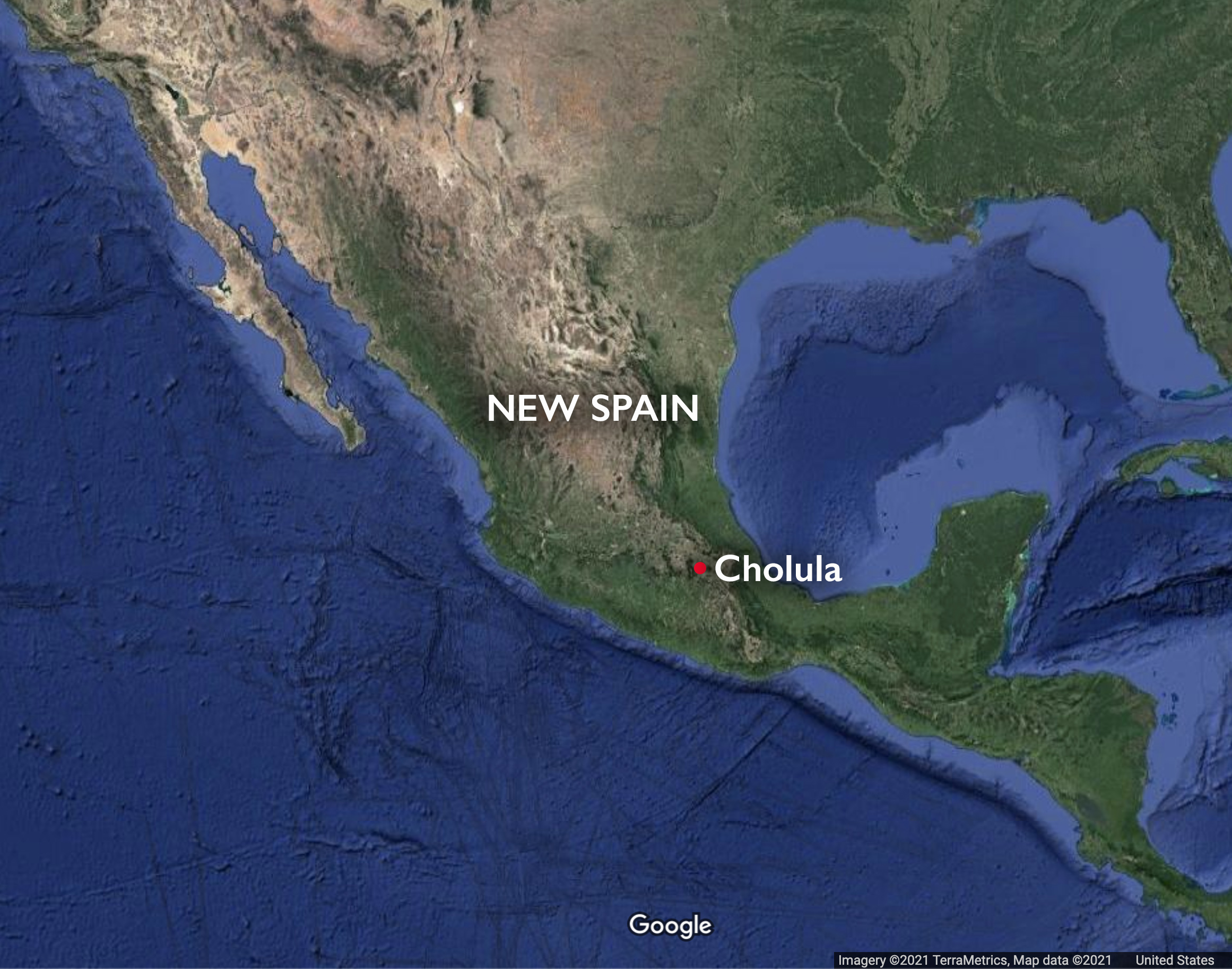
In 1581, an Indigenous artist from San Gabriel, Cholula (near the city of Puebla in Mexico, then part of the viceroyalty of New Spain) created an extraordinary map that shows the main buildings and spaces of the city—all centered around the convento of San Gabriel and the plaza mayor (or main plaza).
How did this remarkable map come to be? In 1577, the King of Spain (Philip II) asked towns throughout the Spanish viceroyalties to complete a questionnaire that included 50 questions about the terrain, built environment, demographics, natural resources, and more. The goal was to help the Spanish Crown gather information about its territorial possessions. The responses are now known as the relaciones geográficas. One of the questions asked for a map (on the questionnaire it is called a pintura or painting), and requested that it include the town’s center, streets, plazas, monasteries, and other important features.
Answers to the survey and the map would be separate objects, although they were intended to be kept together. For the map, the Spanish corregidor of Cholula (the local administrator), Gabriel Rojas, answered the questions on the survey, while a currently unidentified Indigenous artist produced the map—both of which would be sent back to Spain. Because these maps were largely produced by Indigenous artists (indicated by the use of such elements as Indigenous language inscriptions or imagery), they provide important insight into how they visualized space in the wake of colonization and also the visual entanglements and negotiations that occurred as a result of different cultures coming into contact. The materials, iconography, textual inscriptions and more speak to these entanglements.
The convento of San Gabriel
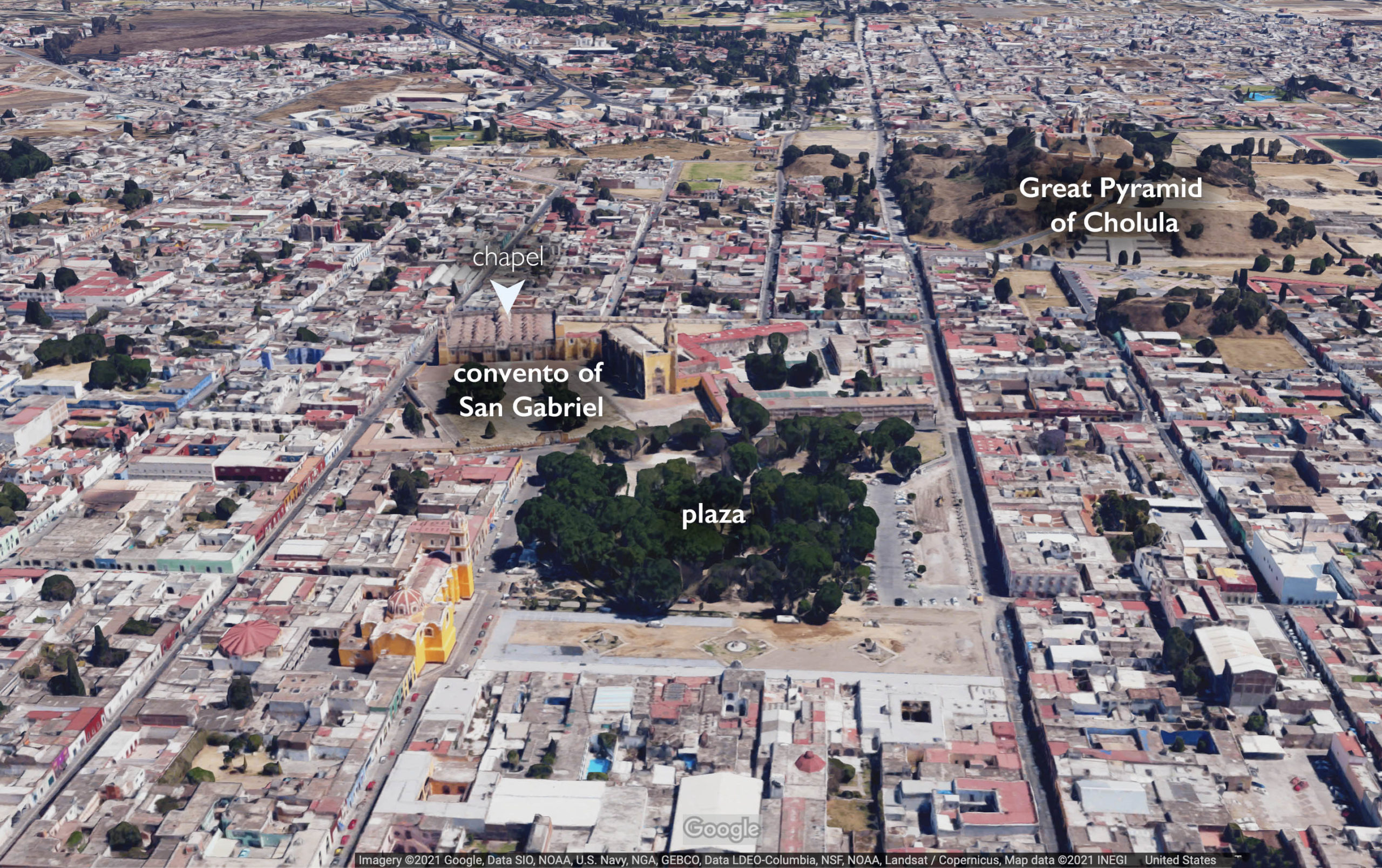
Aerial map of San Gabriel Cholula (underlying map © Google)
The map is organized on a grid—as was the actual city it represents. At the map’s center is the large Franciscan church of San Gabriel, which takes up two city blocks. It is clearly the most important building on this map—even more than the buildings of government below it. This church (part of a convento) was founded by the Franciscans, the first mendicant order to arrive in New Spain, as an aid in converting the Indigenous peoples.
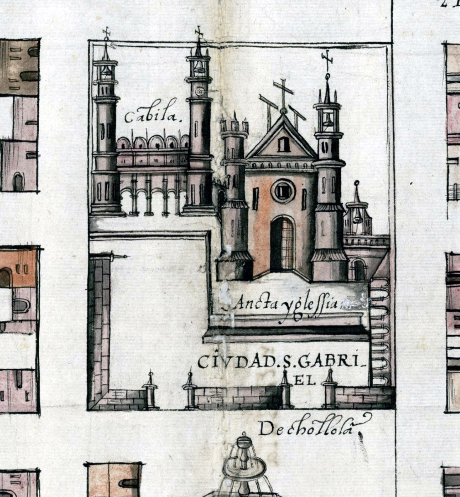
The convento of San Gabriel and the royal chapel (detail), map of Cholula, from the relaciones geográficas, 1581, 31 x 44 cm (Benson Latin American Collection, University of Texas)
The convento’s royal chapel is on the left (on the map, it’s labeled ‘cabila’ which is a variant of capilla), connected to the church. Its distinctive many-domed ceiling is visible, as are its bell towers. Despite its name, the chapel was not meant for royalty, but for the local population to gather and worship. The chapel has an open arcade on the front (both in the map and still extant today), and inside the chapel there is an undifferentiated space filled with columns—similar to a hypostyle hall such as we find in a mosque like Spain’s Great Mosque of Córdoba. Other open chapels built primarily for Indigenous peoples in the early colonial period also used this form, and it is likely that making the structure look like a mosque was both functional (to accommodate large numbers of people) and symbolic (the more recent waves of conquest throughout Iberia had involved transforming mosques into Christian spaces). The convento of San Gabriel also was built with an atrium (open courtyard) to accommodate the large numbers of new Indigenous converts, around which a wall was constructed to demarcate the sacred space, also included in the map.
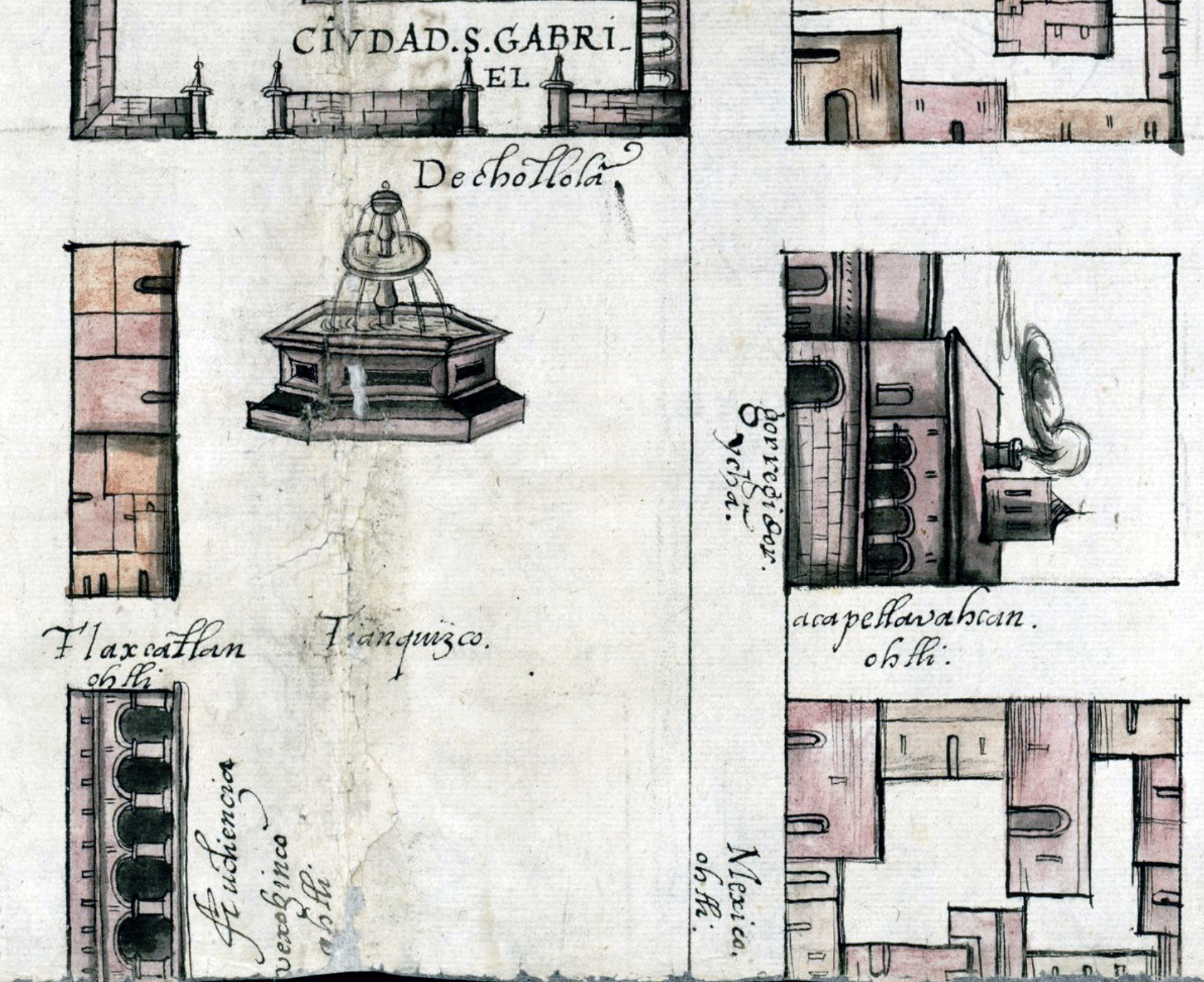
Fountain, plaza and marketplace (detail), map of Cholula, from the relaciones geográficas, 1581, 31 x 44 cm (Benson Latin American Collection, University of Texas)
The city center
The artist has drawn a fountain directly below the convento, and to the left we see a series of connected buildings, and below that an arcaded building. This is the city square (the plaza) in which the city’s main marketplace (labeled as tianquizco, the Nahuatl word for marketplace) was situated (and still is today). The arcaded building is where the cabildo, or town’s government, was located. On the opposite side of the square is the corregidor’s residence (labeled gorregidor ychā), a multi-storied building with an arcaded balcony on the second floor. Roads leading out of the city are also indicated around the square, all labeled with the name of a town and the Nahuatl word ohtli (path or road)—they head to Tlaxcala, Acapetlahuacan (today, Izúcar de Matamoros in Puebla), Huejotzingo, and Mexico City.
The barrios
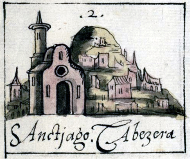
A church in a specific altepetl (detail), map of Cholula, from the relaciones geográficas, 1581, 31 x 44 cm (Benson Latin American Collection, University of Texas)
Surrounding the city center, we see city blocks outlined in black ink filled with smaller unnamed structures (homes and other types of buildings) and six churches, that occupy a full block and are often shown from the front or side, and in connection with a mountain (or tepetl in Nahuatl) to designate a location (not because there was necessarily an actual mountain; explained more below). They are all labeled with a name and a number, such as “2. Sanctiago Cabezera,” and they represent barrios (neighborhoods) of the city.
Cholula has many churches, even today, and many of the early ones were built directly atop Indigenous places of worship. The way the churches are depicted was likely influenced by imported European prints. The artist used light and shadow to model them, giving them a three-dimensional quality, which was a European renaissance artistic strategy introduced to this area.
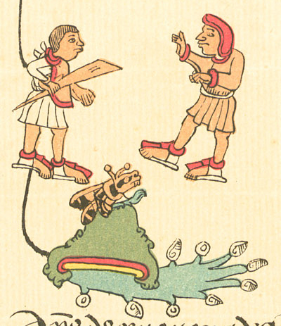
Tollan Cholula (detail), map of Cholula, from the relaciones geográficas, 1581, 31 x 44 cm (Benson Latin American Collection, University of Texas)
Tollan Cholula
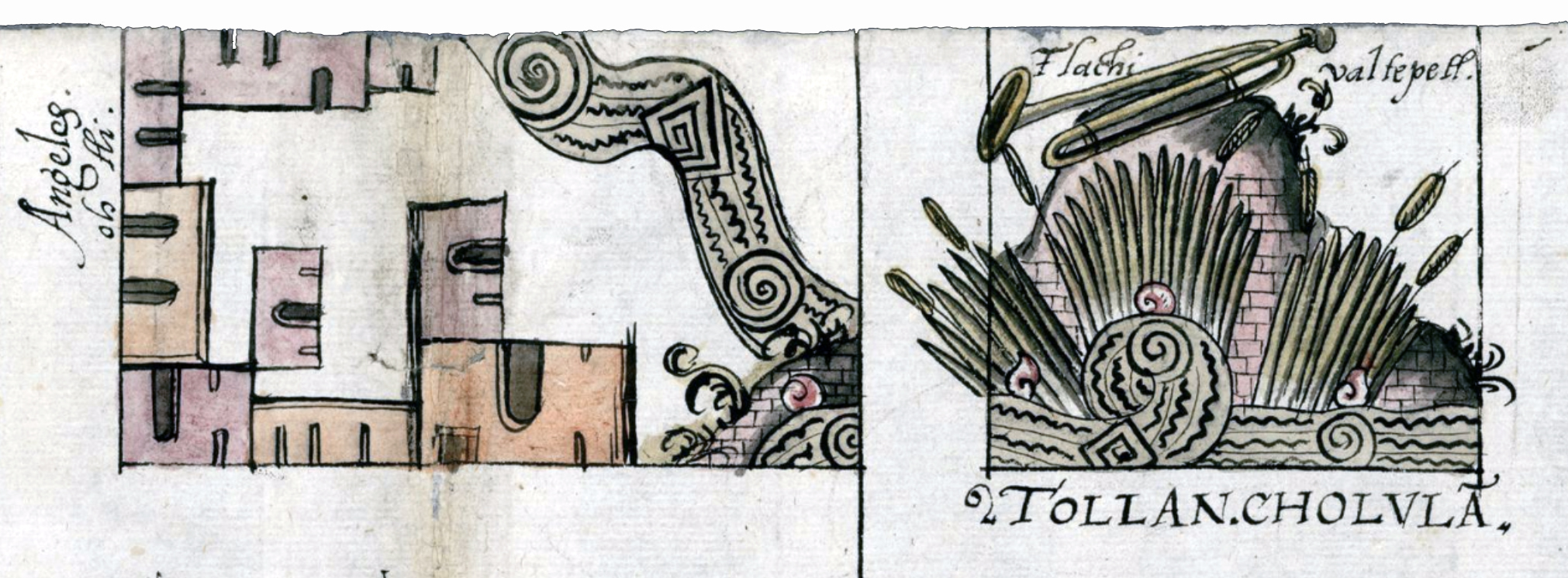
One of the most interesting features of the map is a block on the top right that shows Tollan Cholula, the thriving Mesoamerican city that was here before the colonial era (Tollan means, “among the reeds”; Cholula comes from acholloyan, or the “place where the water flows”). This site is indicated by a Native place sign which combines a mountain with a trumpet, the native atl sign (the sign for water, shown like a spiral in the water), and reeds.
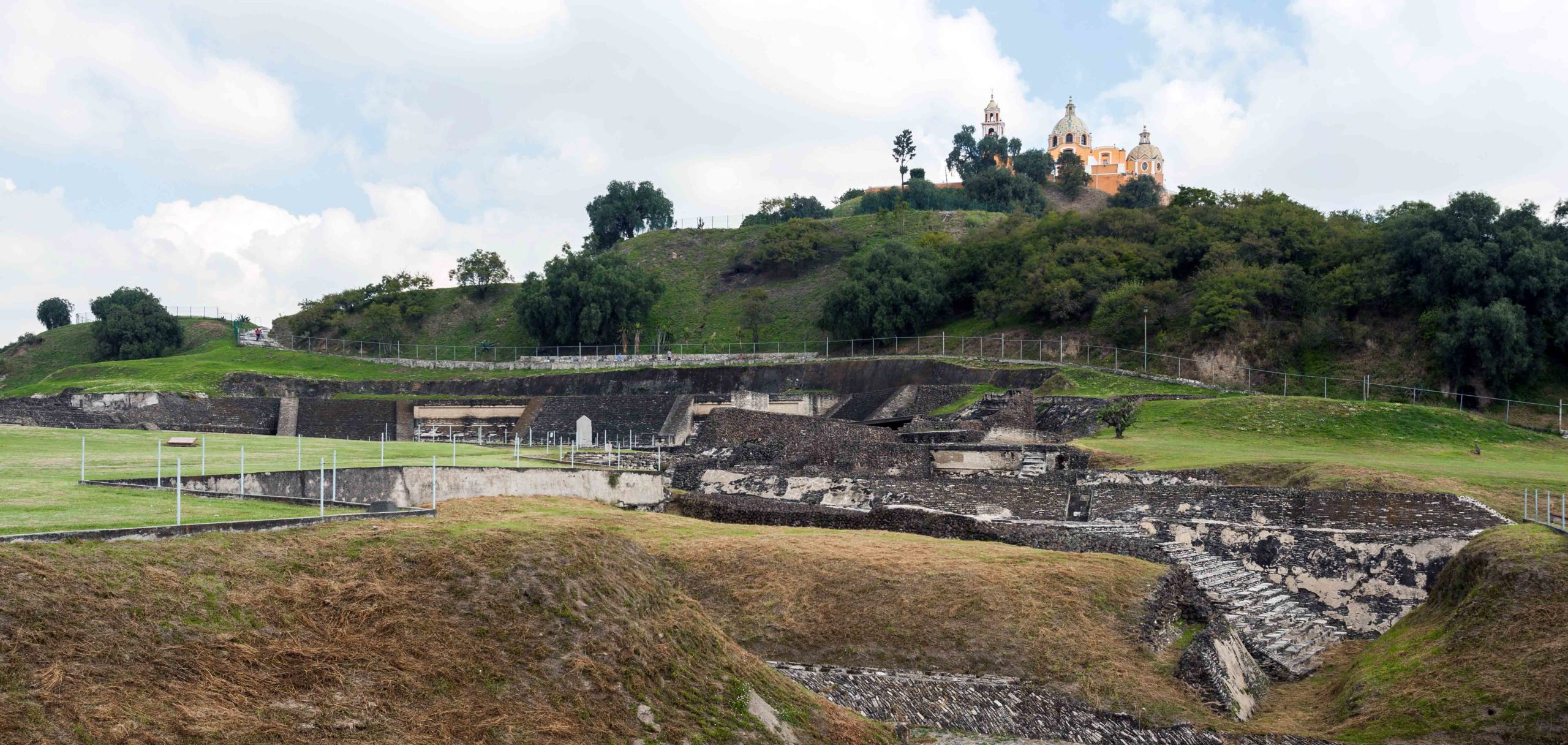
Great Pyramid of Cholula, now partially overgrown (with the small church of Our Lady of Remedies atop it), Cholula, Puebla, Mexico (photo: Diego Delso, CC BY-SA 3.0)
It marks the place of the famous pyramid that was once the thriving center of the city before the Spanish Invasion. Cholula’s massive pyramid still stands today, one of the largest in the world and the biggest in the Americas. Cholula was also the supposed birthplace of the deity Quetzalcoatl (“feathered serpent”), one of the oldest divine presences in Mesoamerica. On the map, the pyramid and the water connected to it are the only forms that spill into other blocks on the map, highlighting its significance to the city, and likely to the artist.
Painted by an Indigenous artist-scribe
The location of Chapultepec, for example, would include a hill (tepetl) and a grasshopper (chapolin). Detail, Codex Telleriano-Remensis, 16th century, folio 45v (Bibliothèque nationale de France)
The artist is believed to be Indigenous not solely because of the prominence of the pyramid and the use of the Native place sign, but also because the map includes text in Nahuatl. Atop the pyramid is the word ‘Tlachivaltepetl’, another name for the pyramid (today spelled Tlachihualtepetl); it literally means “built mountain” or “man-made mountain.” Its importance on the map also refers to the concept of the altepetl (in Nahuatl atl is water, and tepetl is mountain). Altepetl referred to a specific socio-political unit (something like a city-state) found among the Indigenous peoples. On maps, Nahua artists often used the image of a mountain in association with other glyphs or symbols to denote a specific altepetl. The tepetl or mountain glyph designated a specific place; the addition of other symbols (like reeds or a trumpet) helped to identify the specific place. This convention was a common feature of Indigenous maps before and after the Spanish Conquest. The city of Tollan Cholula (recall that it means “among the reeds” and “place where the water flows”) has the mountain, a trumpet, the Native sign for water, and reeds.
The Indigenous artist was likely a tlacuilo, an artist-scribe, someone who both divined knowledge and recorded it in visual form. The tlacuiloque (the plural of tlacuilo) were an important class of individuals prior to the Spanish invasion and conquest, responsible for producing painted pictographic codices that contained knowledge about history, myths, the gods, and more. Many of the manuscripts and maps (like this one) produced after 1521 were painted by tlacuiloque.
Map of Cholula, from the relaciones geográficas, 1581, 31 x 44 cm (Benson Latin American Collection, University of Texas)
The power of the grid
The grid plan had conceptual and literal power at this time too. Cities developed after the waves of Spanish conquests in the Americas were sometimes built on a grid plan. Others were symbolically conceived as grids (although not necessarily built as such), and still others were only visually represented as grids because of the symbolic weight of the plan. The grid plan had associations with order, as well as ties to ancient Roman building practices and ideas about power and imperialism. While the grid plan here was likely connected to Spanish imperial ideas, it is important to note that some cities and towns in Mesoamerica developed grid plans (such as Teotihuacan), so this urban plan was not unique to Europe.
Translation and entanglement
The relaciones geográficas, of which this map was a part, are remarkable moments of translation. The original questions disseminated by order of the King were written in Spanish. Once they made their way around the viceroyalty to towns and cities with a prominent Indigenous population, the questionnaire was then translated into the local language (such as Nahuatl). The questions were then answered in the Native language before being re-translated back into Spanish. The map is another act of translation because it records information in both visual and textual ways, and often includes Spanish and the local Indigenous language.
The entanglements of different traditions are also reflected by the materials. Both imported and local pigments are found on the map. One of the local pigments is cochineal, which created a red color. The paper is imported European paper, and includes a water mark, although some maps are done on locally made paper.
The map of Cholula, while only one map of many that formed the relaciones geográficas, provides insight into the Spanish imperial project in the 16th century, Indigenous artists working in the early colonial era, cultural entanglements, and the conceptualization of space. They also testify to the importance of visual materials as forms of documentary evidence.